
Short in distance, demanding in effort
The park guide consulted lists the circuit at 3.7 km and about three hours, starting near 95 m and reaching roughly 520 m. The sign photographed at the entrance also says 3.7 km from the site to Pedra Jesus Vem, without clarifying whether that is one way or the total. The elevation difference is about 425 m; that is not the cumulative ascent and descent, which I could not find published.
I would not call this an easy walk just because it is under four kilometers. The effort includes climbing, Realengo’s heat, uneven ground and a final rocky section. Reaching the top is optional; a responsible hike can also mean turning back before a passage that does not feel right.
What makes this circuit special
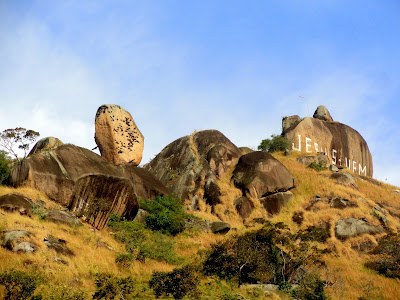
The route brings together Atlantic Forest, large boulders and rock walls. Pedra do Osso stands out for its upright shape and narrow base; Muro das Lamentações is a large rock wall; and Pedra Jesus Vem crowns the group. For me, watching the rocks change shape along the way is central to the visit.
INEA and the trail guide list Núcleo Piraquara as the access point for this area. The Transcarioca guide also describes Section 08 as a related route, but its 4.6 km and three hours apply to that full section, not to Circuito Pedra Jesus Vem.
The rocky passage and cable
The reference material describes the approach to the upper part of Jesus Vem as a scrambling section supported by a steel cable. I could not confirm the cable’s condition, maintenance or availability for 2026. I therefore do not recommend relying on it or attempting the climb without checking with park management and having appropriate rock experience.
If you have vertigo, find the rock wet or do not feel safe at the passage, you can stop. The rocks, forest and landscape still make for a worthwhile outing without reaching the highest point. This page notes the historic existence of the passage; it does not teach climbing, protection or descent techniques.
Suggested start time
INEA lists park visiting hours Tuesday to Sunday, 8 am to 5 pm. For the three-hour reference circuit, I would start between 8 and 9 am, leaving time for breaks and a return before closing. That is my planning suggestion, not an official circuit start time. Confirm opening, notices and visitor limits with the site before setting out.
I would avoid a late start. After rain, rocks, roots and mud lose traction; with a storm, strong winds, extreme heat or dense fog, I would switch to an easier visit near the park site.
Access, map and preparation
The general entrance is Núcleo Piraquara, at the end of Rua do Governo in Realengo. This guide’s map marks the site, not every point on the circuit. Check the Transcarioca map and cartography, download what you need offline and confirm with the park which route is open. Do not rely on cell service as your only navigation tool.
I would bring enough water, food, grippy footwear, sun protection, insect repellent, a charged phone, power bank and basic first-aid kit. Hiking poles can help on some stretches but may get in the way if you need your hands. Do not count on refilling water without checking each point in advance.
Who I recommend it for
I recommend this hike for people with moderate fitness and mountain-trail experience. I do not present it as universally suitable for children or wheelchair accessible. Older visitors, families and inexperienced hikers should consider elevation, heat, ground conditions and whether to skip the final passage; a local guide can help interpret the route.
Ernestinho's tips
Before setting out, tell someone your plan, check the forecast and read park alerts. Stay on the trail, do not mark or alter rock formations, carry out your trash and do not make fires. If conditions change, turn back early; in the mountains, returning in daylight is part of the outing.
What to combine it with
To understand each part of the circuit, read my guides to Pedra Jesus Vem, Pedra do Osso y Muro das Lamentações. On another visit, you can explore Núcleo Piraquara and Cachoeira do Barata; INEA lists the latter as the park’s only waterfall open for swimming. Check current conditions before combining outings, and do not add trails if your schedule is already tight.
Planning sources
INEA: Pedra Branca State Park → · Transcarioca Trail: Section 08 guide and map →
